
Revised 27 January 2022
Accepted 21 November 2022
Available Online 10 January 2023
- DOI
- https://doi.org/10.55060/s.atssh.221230.010
- Keywords
- Downstream Yuan River basin
Water god temples
Cultural value
Ancient hydrological value
Climate change - Abstract
There are many water god temples in the downstream basin of Yuan River in Hunan Province. In ancient times the water god temples, which were regarded as the water god belief, were built on the water to pray for the safety of water traffic and to guide the waterway. Today, they are endowed with cultural value for the tourism economy. Due to the particularity of the water god temples being built by the water, the sites mark the shoreline of the ancient Yuan River. On the other hand, the construction base of the water god temples needs to be higher than the water level of the year. This article reveals the relationship between the water god temples in the downstream basin of the Yuan River and the environmental value of ancient water, that is, trying to use the height of the base of the water god temples to represent the elevation of the water level of the ancient river, in order to compare the changes of the highest water level and the characteristics of drought and flood in different periods of history. This study can provide reliable evidence for paleoclimate changes during the Qing Dynasty.
- Copyright
- © 2022 The Authors. Published by Athena International Publishing B.V.
- Open Access
- This is an open access article distributed under the CC BY-NC 4.0 license (https://creativecommons.org/licenses/by-nc/4.0/).
1. INTRODUCTION
There are many water god temples located in the downstream area of Yuan River, the second largest river in Hunan Province, from Taoyuan to Dongting Lake. These water god temples include stone cabinets, pavilions, temples, temples, palaces, halls, nunneries, and towers. The construction of the water god temples originated from the deity and personification of water worship by ancient people and produced a series of water gods and water god belief cultures. At present, the local government has developed a series of modern tourism economy and culture around the remains and ruins of the water god temples. However, the historical water god temples were built according to the water, and the construction height of the water god temples generally exceeded the highest water level in history, reflecting the data of the highest water level in the river at that time. It was rebuilt many times due to flood damage, making it the physical records of paleohydrological changes of downstream basin of the Yuan River. In addition, combining ancient books and documents, remote sensing images and field investigations, people gather to form commercial and economic points due to religious beliefs; because the water god temples were usually built at the intersection of the two waters, they became water transportation hubs, and they also acted as beacons for the safety of water transportation; under special circumstances, the water god temples were built at high places and also played a military role as beacon towers. It can profoundly reveal the paleohydrology value of the water god temples.
Li Junjie's research in “The World of Water Gods Gone: The Types and Regional Distribution of Water God Sacrifice in Shanxi in Qing Dynasty” [1] pointed out that in the Qing Dynasty, Shanxi water god sacrifice activities were affected by national sacrifice policy and local historical environmental factors. The water god sacrifice here is a kind of living custom, a social system, permeating the local society, and having independence. The so called “water god” is not just because of the “water”. People worship the water god in the hope of good weather, avoiding floods and droughts, and showing the traditional society's dependence on agriculture. Tian Mi's research [2] shows that from the perspective of human geography, the water conservancy changes in the Wanjiagou small watershed of the Yellow River Hetao since the Qing Dynasty and the evolution of the human society in Mongolian banners are described. From the early Qing Dynasty to the Republic of China, Tian Mi expounds the relationship between the regional society brought about by the use of water and floods with different functions in different villages. Around 1950, due to the change of national policies, the water conservancy order in the Wanjiagou small watershed was re-established, and the custom of worshipping the water god still continues today, which actually reveals that the local people yearn for the right to use this important resource of water. It can be seen from the above discussion that the existing literature related to the belief in the water god or the water god temple focuses on the cultural value itself, and involves less on the scientific level of the hydrological environment such as the change of the river course.
“Climate change and the rise and fall of human history is an extremely complex interdisciplinary issue” [3]. Based on summarizing the cultural value of water god temples in the downstream basin of the Yuan River, this article explores paleohydrology (river shoreline and water level elevation) elements of the water god temples in order to reflect their paleohydrological value and paleoclimatic significance.
2. THE DISTRIBUTION LAW OF THE DOWNSTREAM BASIN OF YUAN RIVER AND THE WATER TEMPLE
2.1. Downstream Basin of Yuan River
“The Yuan River originates in the southeastern part of Guizhou, and has two sources, the south and the north. The southern source of the Longtou River originates from the southern foot of the Miaoling Doubeng Mountain in Guiding County, Guizhou Province, and the northern source of the Chong'an River originates from the mountains between Pingyue, Majiang County, Guizhou Province. The two sources are called ‘Qingshui River’ after they converge at the fork in Panghai Town, Kaili City, and it is called ‘Yuan River’ when it reaches Luan Mountain and flows into Zhijiang County, Hunan Province, and flows eastward to Tuokou Town, Hongjiang City, where it joins with Canal Water” [4]. The downstream of Yuan River flows 23 km southeast to Nawu River in Hongjiang Town, then to Xupu River estuary to absorb Xu River, to Chenxi to integrate with Chen River and then to Wuqiang Stream Reservoir Area, then to Luxi to absorb Wu River, and to Yuanling to integrate with You River, Yi Stream and Dongting Creek. After leaving Wuqiang Stream Reservoir, it passes through Nayiwang Creek and Baiyang River in Taoyuan County, and then flows into Dongting Lake from Deshan in Changde City. The main stream is 1,033 km long, and the length in Hunan is 568 km. The key research area of this article is the downstream basin of Yuan River (Fig. 1), namely Taoyuan County, Wuling District, Dingcheng District and Hanshou County in Changde Region of Hunan Province. The downstream of Yuan River ranges from Yuanling Town, Yuanling County to Potou Town, Hanshou County. Yuanshui River runs 120 km in Changde City, with a drainage area of 5,086 km2.
2.2. Distribution Law of Water God Temples in the Downstream Basin of Yuan River
The author sorted out the following 40 ruins related to the water god temples through field investigation, and recorded its construction, destruction, and reconstruction years through literature records, oral descriptions, and physical objects. The specific parameters are shown in Table 1. The author also made a spatial distribution map of the water god temples in different geographical units (Fig. 2).
Fig. 2 shows that the main bodies of the water god temples concentrated in the plain area and the transition zone between hills and plains. The reason is that the rivers in the plain area change frequently, and the water god temples that serve the navigation of the river, the collection and distribution of materials, and the population activities need to be matched with them. The transition zone between hills and plains is the intersection of mountain rivers and plains, which also responds to the service function of the water god temples. There are no water god temples in mountainous areas such as the west because that the current is fast, it is not suitable for shipping, and there is no need for a water god temple. From the perspective of spatial distribution, the water god temples reflect the simple cultural value.
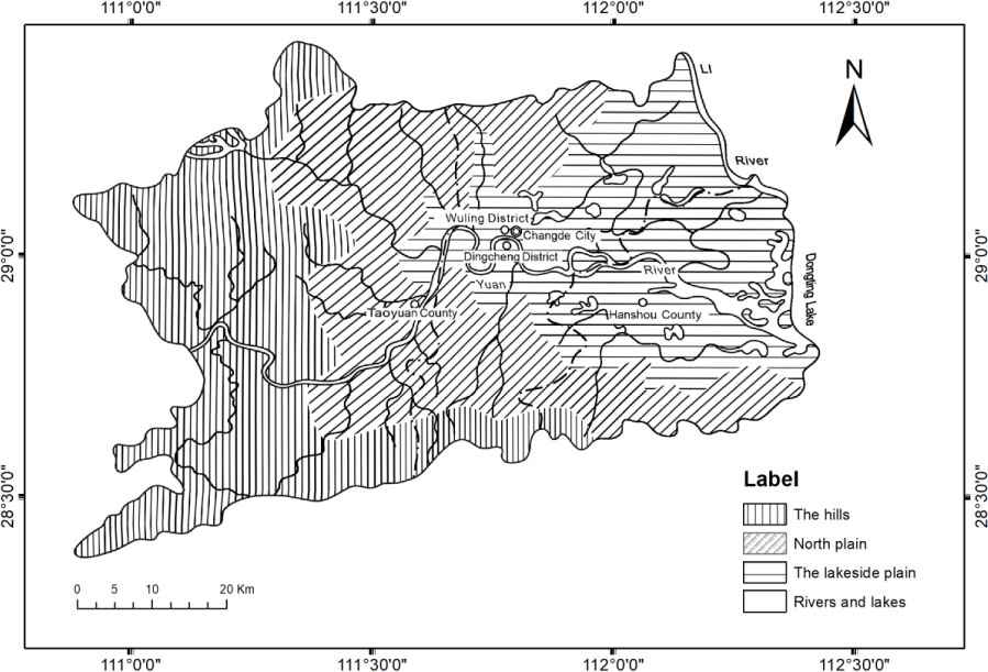
Topographic zoning map of the lower reaches of the Yuan River [5].
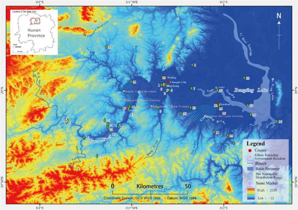
Distribution map of 40 water god temple sites in the downstream basin of the Yuan River.
| Serial Number | Targeting Name | Longitude | Latitude | Altitude (m) | Brief |
|---|---|---|---|---|---|
| 1 | Luolukou stone marker, in the area of Chengxi Sub-district Office, Wuling District, Changde City | 111.6600561 | 29.02913599 | 42.0 | It is an important flood control and waterproof facility in the ancient city of Changde. It is roughly in the shape of a trapezoid. It was built in the 34th year of Qianlong (1769). |
| 2 | Shawan stone marker, in the area of Chengxi Sub-district Office, Wuling District, Changde City | 111.6962594 | 29.02361902 | 33.9 | The Shawan stone marker of the Sanguan Hall in the east of the city was built during the Five Dynasties and Ten Kingdoms period (923) and is located on the north bank of Yuan River outside the city embankment. |
| 3 | Beacon City stone marker, Guangming Lane Community, Chengxi Sub-district Office, Wuling District, Changde City | 111.6832474 | 29.03135401 | 39.0 | The marker is now arc-shaped from east to west, with a length of 84 meters from east to west. The north is connected to the Changde flood control embankment. It is 22 meters long and 7 meters high from the arc top of the cabinet to the north. It was built around 960 in the Song Dynasty. |
| 4 | Huamaodi stone marker, Yuan'an Road, Xidi Community, Chengxi Sub-district Office, Wuling District, Changde City | 111.6731306 | 29.03324924 | 44.0 | Located within the flood control levee on the north bank of Yuanshui River, it was built in the seventh year of Emperor Kangxi of the Qing Dynasty (1668). |
| 5 | Shangnanmen stone marker, Xidi Community, Chengxi Sub-district Office, Wuling District, Changde City | 111.6772795 | 29.03288978 | 42.0 | Founded in the late Tang and early Five Dynasties (907 years), it has been preserved until now, with a history of more than a thousand years. |
| 6 | Stone marker of Sifeng Temple, Group 2, Huangmuguan Community, Chengdong Sub-district Office, Wuling District, Changde City | 111.7007778 | 29.0019167 | 41.0 | Located on the east bank of Yuan River, it was built in the 48th year of Wanli in the Ming Dynasty (1572) and rebuilt in the 31st year of Emperor Qianlong of the Qing Dynasty (1767). |
| 7 | Shuifu Nunnery, Zhugentan Village, Nanping Street, Wuling District, Changde City | 111.6679048 | 29.07004936 | 33.8 | In the first year of Tongzhi in the Qing Dynasty (1862), in order to pray for a safe trip, the ancients built a water house here to enshrine the God of Chuanzi River. |
| 8 | Wanshan Temple, Zhiwan Village, Niubitan Town, Dingcheng District, Changde City | 111.8241497 | 29.01079508 | 39.7 | Wanshan Temple was built in Song Dynasty, it was built in the third year of Duanzong Zhao Gang Jingyan in Song Dynasty (1278), so far it has a history of more than 700 years. |
| 9 | Zhuizi Tower, Water Margin Temple Community, Zhendeqiao Town, Dingcheng District, Changde City | 111.8280128 | 29.13875632 | 51.3 | Zhende Bridge belongs to the lake area. During the Xianfeng period of the Qing Dynasty (1851), a temple was built beside the Tashui Bridge for the floods, named Water Margin Temple. |
| 10 | Tiansixian Temple, Shuangyangang Village, Doumhu Town, Dingcheng District, Changde City | 111.6411372 | 28.90526328 | 55.0 | Tianzigang, also known as Tiansigang, is located in Shuangyangang Village and is the birthplace of Zhong Xiang, the leader of the Dingli peasant uprising in the Southern Song Dynasty. At the end of the Qing Dynasty (1898), Tiansixian Temple was built, with a pagoda standing in front of the temple, but it has not been rebuilt today. |
| 11 | Shuifu Pavilion, Shuixi Village, Taohuayuan Town, Taoyuan County, Changde City | 111.4288872 | 28.80041296 | 109.8 | Shuifu Pavilion was built in the Ming Dynasty (1368) and stands on the top of Taoyuan Mountain. |
| 12 | Wenchang Pavilion, Yuan River Scenic Belt, Zhangjiang Town, Taoyuan County, Changde City | 111.4846092 | 28.90388295 | 41.6 | Located on the east side of the stone marker in the scenic zone of Yuan River in the county seat, formerly known as Chuanshang Pavilion. It was built in the sixth year of Yanyou in the Yuan Dynasty (1319) and was destroyed at the end of the Yuan Dynasty. It was rebuilt twice in the 25th year of Jiajing of Ming Dynasty (1546) and the seventh year of Wanli of Ming Dynasty (1579). In the 51st year of Emperor Kangxi of the Qing Dynasty (1712), it was rebuilt and changed to its current name. |
| 13 | Stone marker at Yuan River scenic belt in Zhangjiang Town, Taoyuan County, Changde City | 111.4830664 | 28.90187615 | 49.0 | Located on the scenic belt of Yuanshui in the county seat, it was built three times in the 7th year of Yanyou in Yuan Dynasty (1320), the 16th year of Jiajing in the Ming Dynasty (1537), the 36th year of Wanli in the Ming Dynasty (1608), and the 45th year of Qianlong in the Qing Dynasty (1780). |
| 14 | Zhangjiang Pavilion, Zhangjiang Town, Taoyuan County, Changde City | 111.4885438 | 28.91182497 | 40.6 | Zhangjiang Pavilion was built in the Hongwu period of Ming Dynasty (1368), was blown up by Japanese air raids, and rebuilt in the 37th year of the Republic of China. |
| 15 | Wanshou Palace, Neighborhood Committee of Wanshou Palace, Shaping Town, Taoyuan County, Changde City | 111.31342 | 28.64262 | 94.0 | In the middle section of Shaping Ancient Street, there is a Wanshou Palace with an antique architecture. It was built in the 35th year of Emperor Qianlong's reign (1770) in the Qing Dynasty. It was demolished in the late 1960s and has now been renovated as a hospital. |
| 16 | Yangsi Temple, Fengyu Bridge, Shaping Brigade, Shaping Town, Taoyuan County, Changde City | 111.3109306 | 28.64163327 | 64.0 | At the end of the Qing Dynasty (1898), a Fengyu bridge was built on the Chengxi River at the entrance of Shaping Shangjie. It was named the Big Bridge. The bridge was 70 meters long and 3 meters wide. |
| 17 | Fubo Palace, Chuanshi Village, Lingjintan Town, Taoyuan County, Changde City | 111.2391907 | 28.74423154 | 61.7 | Located in Chuanshi Village, Lingjintan Town, Fubo Palace was built in the Ming Dynasty (1368) on the north bank of the Yuan River. The statues of Ma Yuan and General Yang Si are enshrined in Fubo Palace behind the pavilion, which were rebuilt in 1992. |
| 18 | Tiantai Mountain Temple, Jianjiaxi Neighborhood Committee, Jianshi Town, Taoyuan County, Changde City | 111.3821216 | 28.78372111 | 69.2 | Oral statement: It was built in the ninth year of Hongwu period of Ming Dynasty (1376), destroyed in 1956, and then rebuilt with donations from villagers in 2012. |
| 19 | Lotus Temple, Mumakou Village, Xinglong Street Township, Yiwangxi Town, Taoyuan County, Changde City | 111.1507696 | 28.83552664 | 63.0 | Oral statement: Built during the Tang Dynasty (618), destroyed around 1950 |
| 20 | Shuixin Nunnery, Yiwangxi Scenic Area, Xinglong Street Township, Yiwangxi Town, Taoyuan County, Changde City | 111.143087 | 28.82808917 | 91.7 | Also known as “Bingxinyan”, Yang Yao, the leader of the peasant uprising in the Dongting Lake area in the early Southern Song Dynasty (1127), set up camp on the top of the mountain, set up an altar, and prayed to the sky. |
| 21 | Yuntou Xianshan Temple, Yangjiaping Village, Shuangxikou Town, Taoyuan County, Changde City | 111.3608839 | 29.23593862 | 64.8 | Before and after the 25th year of Hongwu in Ming Dynasty (1392), it was named Shuangxikou because the two streams of Jie Stream and Tang Stream intersected here. |
| 22 | Yang Si Temple, Fengshu Uyghur Hui Village, Zoushi Town, Taoyuan County, Changde City | 111.4960042 | 29.04641541 | 34.8 | Located in Zou City, “Zou” means gathering, it was built in the late Ming and early Qing Dynasties (1600), and it is named after the market formed by the convergence of three rivers. |
| 23 | Xuetao Mountain Temple, Bagongqiao Village, Jianshi Town, Taoyuan County, Changde City | 111.3734238 | 28.81933372 | 38.9 | Yangsi Temple in Bagongqiao Village is located in Jianshi Town in the central and southern part of Taoyuan. It was built during Southern Song Dynasty (1127–1279), destroyed during Cultural Revolution, and rebuilt 3 times later. |
| 24 | Emei Mountain Immortal Hall, Bagongqiao Village, Jianshi Town, Taoyuan County, Changde City | 111.3684366 | 28.80226339 | 89.4 | Oral statement: Built during the Qing Dynasty, destroyed at the beginning of the Cultural Revolution and rebuilt in 1982. |
| 25 | Qigu Immortal Hall, Bagongqiao Village, Jianshi Town, Taoyuan County, Changde City | 111.3692397 | 28.81491177 | 97.0 | Oral statement: built during the Ming Dynasty (1368), destroyed during the Cultural Revolution, and rebuilt in 1980. |
| 26 | Wufeng Mountain Hall, Yuhuangdian Village, Jianshi Town, Taoyuan County, Changde City | 111.3528421 | 28.83725008 | 109.3 | Oral: Built during the Ming Dynasty, destroyed during the Cultural Revolution, and rebuilt in 1988. |
| 27 | Jiulong Xianshan Temple, Yuhuangdian Village, Jianshi Town, Taoyuan County, Changde City | 111.3617777 | 28.84415216 | 112.7 | Oral statement: Built during the Qing Dynasty, with the history of more than 200 years, destroyed during the Cultural Revolution. |
| 28 | Ancient Pagoda of Nanchan Temple, Baotahe Community, Longyang Street, Hanshou County, Changde City | 111.9761035 | 28.90285512 | 35.5 | Wenfeng Pagoda, built in the Jiajing period of Ming Dynasty (1522) and rebuilt in the first year of Emperor Kangxi of Qing Dynasty (1662), has seven levels and eight sides and a height of 33.27 meters. Yuan River circles around the temple. |
| 29 | Yang Si Temple, Linjiashan Village, Cuijiaqiao Town, Hanshou County, Changde City | 112.0542575 | 28.71330973 | 64.8 | Located in the southeast of the county, it is located in the hilly and mountainous area, the terrain is high in the south and low in the north. The bridge water system originates from Linjiachong Forest Farm and flows through Linjia Mountain. |
| 30 | Yang Si Temple, Yudepu Community, Cuijiaqiao Town, Hanshou County, Changde City | 112.0208258 | 28.75388699 | 39.6 | Built in 1133, destroyed in 1958, and rebuilt in 2013. |
| 31 | Taizi Nunnery, Taizi'an Village, Niejiaqiao Township, Hanshou County, Changde City | 111.8188724 | 28.90649412 | 43.0 | The terrain is high in the southwest and low in the northeast, surrounded by water on three sides, basin-shaped in the middle, and located at the top of the upper reaches of Canglang. |
| 32 | Zhenlong Pavilion, Baotahe Community Town, Longyang Street, Hanshou County, Changde City | 111.9761713 | 28.91907862 | 31.7 | Zhenlong Pavilion has been destroyed, and Hanshou No. 2 Middle School was built on it. |
| 33 | Taizi Temple, Taizi Temple Town, Hanshou County, Changde City | 111.9467825 | 28.77235928 | 57.2 | The Taizi Temple is known as a thousand-year-old town. |
| 34 | Yang Si Temple, Yongfengyuan Village, Potou Town, Hanshou County, Changde City | 112.1349909 | 28.91889875 | 37.8 | The town is the water and land transportation hub of Xihu District. It was built during the Qing Dynasty and was destroyed in 1960. |
| 35 | Shuifu Temple, Miaoju Village, Yougang Town, Hanshou County, Changde City | 112.110587 | 29.06773788 | 34.2 | Yougang was named after the You River. It was built in the first year of Guangxu in the Qing Dynasty. In 1954, the Shuifu Temple was washed away, and there was a pagoda. In 1962, the pagoda was destroyed. |
| 36 | Yang Si Temple, Chongtian Village, Yangtaohu Town, Hanshou County, Changde City | 112.1457391 | 28.86744832 | 32.5 | Yangtaohu Town is located on the west coast of Dongting Lake. It is an alluvial plain and is pot-shaped, with high periphery and low center. |
| 37 | Yang Ssi Temple, Shangpin Yeyuan, Chengbei Community, Longyang Street, Hanshou County, Changde City | 111.964709 | 28.91269241 | 39.2 | Longyang Town is adjacent to Yuan River in the north and the Canglang River in the south, which flows through the territory and is 10.63 km long. |
| 38 | Hongguzhou Dragon King Temple, Kongjiahu Village, Bailuqiao Town, Hanshou County, Changde City | 112.2876464 | 28.83082821 | 29.2 | Located at the junction of Bailu Bridge in Hanshou County and Yuanshui County, it was built in the eighth year of Emperor Taizong of Tang Dynasty (635) and rebuilt and expanded during the reign of Emperor Qianlong of Qing Dynasty. It was demolished in 1956 and rebuilt in 1992. |
| 39 | Yang Si Temple, Sujia?? Village, Cantouzui Town, Hanshou County, Changde City | 111.9645445 | 29.00021658 | 38.4 | The Sujia?? is located in the town of Cantouzui, in the extension of the Xuefeng Mountains to Dongting Lake. |
| 40 | Baima Temple, Baima Village, Niejiaqiao Township, Hanshou County, Changde City | 111.7679797 | 28.87492787 | 50.5 | The terrain of Baima Village is high in the southwest and low in the northeast, surrounded by water on three sides and basin-shaped in the middle. |
Information overview of the water god temples in the downstream basin of the Yuan River.
“The belief in General Yang Si flourished in the Yangtze River Basin during the Ming and Qing Dynasties. Temples dedicated to General Yang Si and townships, villages, roads, wharves, and ruins named after Yang Si were distributed in Hunan, Hubei, Anhui, Jiangsu, etc. five provinces and cities” [6]. It can be used to prove the changes of the ancient riverbank. The rivers and lakes in Changde City are densely covered, the harbor is vertical and horizontal, and the Yang Si Water God Temple is built along the water. In terms of distribution, several characteristics are summarized: First, it is used as a beacon and beacon to indicate the direction of the channel, boundaries and obstacles, etc. [7], and it is an important measure for the safe navigation of ships. To a large extent, it is built in the accident-prone areas along the waterfront; secondly, it is built as a chamber of commerce in the waterway area. “In recent years, with the reform of the state, the water god temples have been protected by the state, and there is an endless stream of tourists and believers who come to visit and worship here every year” [8].
From the perspective of the relationship between the river channel and the water god temples, most of the water god temples are built along the main stream of Yuan River, including the banks of ancient river channels left over from history; a small number of water god temples are built on the banks of the tributaries of Yuan River. These relationships reflect the value of paleohydrology.
3. ANCIENT HYDROLOGICAL VALUE OF THE WATER GOD TEMPLES
Historically, the water god temples were built on water and rebuilt many times due to flood damage, making them physical records of ancient hydrological changes in the downstream basins of the Yuan River. By interpreting the key water god temple sites and relics obtained from field investigations, they can be used to locate ancient riverbanks and serve the restoration of ancient river channels and ancient water level elevations, and can serve the research on ancient climate change.
3.1. Positioning of the Ancient Riverbank of the Water God Temples: Restoration of the Ancient River Channel
“The river topography is the product of a series of driving forces. Precipitation, temperature, and gravity promote changes in landforms and opposing frameworks that resist change (controlled by lithology, stratigraphy, and structural characteristics of underlying materials). Ideally, the interplay of these driving forces and resistances results in the form of the landscape being subtly tuned to the process of creating it” [9]. Due to the large annual average runoff of the Yuan River and the strong erosion of the riverbank, the riverbed has undergone many changes in history. It is obviously difficult to draw correct conclusions on how to restore the river conditions in the Qing Dynasty only by relying on literature records and remote sensing images. The sites of the water god temples, which are of great significance as historical river navigation beacons and material distribution points, can express the ancient riverbank and ancient water level in the form of physical objects.
Zhenlong Pavilion, formerly known as Xihua Temple, faces Yuanshui in the north and hills in the southwest, and is located in the West Dongting (Fig. 3). The northeastern lakes are connected with vast waters. From south to north, generally the hills gradually transition to the Dongting Lake area. Guangxu's “Longyang County Chronicle” records: “Zhenlong Pavilion was built by Zeng Shougui from the Tong County during the Wanli period of the Ming Dynasty. “Pavilion's” is surrounded by water, controlling five streams (Xiong Stream, Man Stream, You Stream, Yuan Stream and Chen Stream in the upper reaches of Yuan River), and the Yangtze River in the north, which stretches for thousands of miles” [10]. Canglang Academy was built in the eleventh year of Qianlong's reign in the Qing Dynasty (AD 1746), and later magistrate Li Zhixie moved it to Zhenlong Pavilion in the forty-fourth year of Qianlong's reign, which is today's No. 2 Middle School in Longyang Town.
There is a place next to Zhenlong Pavilion called Yangqiju, and the third volume of Jiajing's “Changde Prefecture Records: Township in Longyang County” has ‘Pozei Village’ [11]. Here is a story about the uprising of General Yang Si. Yang Yao stationed in the ancient Pozei Village facing the north bank of the river, which is located in Hanshou County in current times. The name of Pozei Village came from Yue Fei's defeat of Yang Yao, and the name of the village still existed until the end of the Qing Dynasty. After field investigation, it was found that the stockade is today's Embankment Reclamation Farm, and a mountain in the northeast called Baotai Mountain, also known as Baotuo Mountain, is located “15 miles to the north of (Longyang) County” [12]. There are many legends in the village. Today, in the northwest of Baotai Mountain, there is Chelun Min, which is said to be the place where General Yang Si once built cars and boats. To the south of the Min is Cangerzong, which is said to be the place where General Yang Si stored grain and grass. In the southeast, there is a lake named Xiaojiwa, which used to be a lake. There are rivers on all sides of the lake that connect with the outer lake. Warships can attack from all sides of Xiaojiwa and return to Xiaojiwa from all sides. It is said to be the naval base of General Yang Si. To the south of Xiaojiwa is Yangqiju, which is said to be the place where General Yang Si raised his flag and carried out an uprising movement [13]. This is why this place is called as Yangqiju, the river already existed in the Southern Song Dynasty, which is enough to prove that this was the ancient riverbank (Fig. 4).
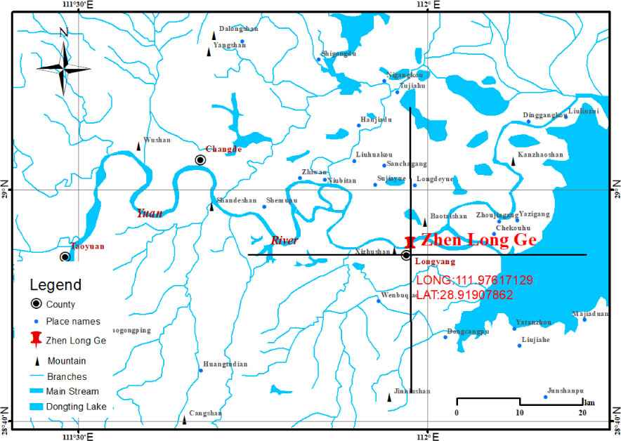
The location of Zhenlong Pavilion water god temple on the map in the late Ming and early Qing dynasties.
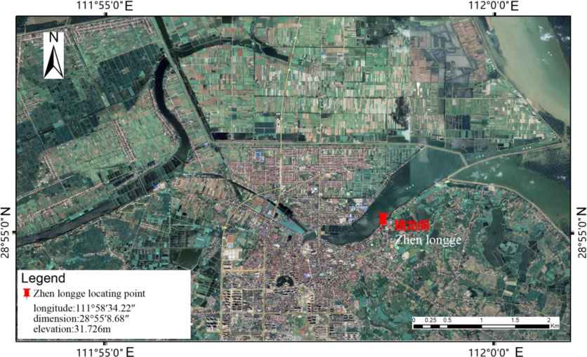
Zhenlong Pavilion records the shoreline of the ancient river.
3.2. Ancient Water Level Elevation of Water God Temples: Paleoclimate Change
The stone markers are important waterproof facilities in the history of Changde City to protect the urban area from floods (Fig. 5). After hundreds of years of raging floods, the markers have collapsed several times, but they have been repaired many times in the dynasties, which can generally maintain their original appearances today. The height and size of each stone marker vary, but most of them were built in the Ming Dynasty and rebuilt or reinforced in the Qing Dynasty. The construction of embankments in Changde County to prevent floods was recorded as early as the Southern and Northern Dynasties.
According to the Biography of Liu Quan · The Book of the Southern Qi Dynasty: During the Yongming Period (AD 483–493), Liu Quan was the prefecture chief of Wuling County. “The ancient river embankment in the south of the county was broken, and Liu Quan rebuilt the river embankment himself.” During the Five Dynasties and Ten Kingdoms period (AD 923), deputy general Shen Ruchang built the upper and lower stone markers (ie, Xidi and Shawo stone markers) in the city of Changde. In the Yanyou year of Yuan Dynasty (AD 1319), the road superintendent Ha Shan of Changde built a stone marker in Bijia City stone marker to repel the flood and protect the city embankment. In the Ming Dynasty, due to the successive blockage of the caves on the north bank of the Jingjiang River, the river swayed to the south, the water level of Dongting Lake rose, and the construction of embankments gradually rose. In the eleventh year of Zhengtong in Ming Dynasty (AD 1446), Daweidi was built in Changde and Hanshou counties. “The length of the river embankment is 3,610 zhang, recording 5,868 acres of land” [14]. During the Jiajing period in Ming Dynasty (AD 1522–1566), nine embankments were built in the county. According to “Changde Prefecture Chronicles” in Jiajing period: The Huaihuadi, 500 meters outside the Qingping Gate of Changde Prefecture, there is an ancient locust tree on the ground, hence the name Huamaodi. Outside the Qingping Gate, there is a big river. In the 13th year of Jiajing (AD 1534), the flood broke the embankment, and the magistrate Zhong Luan rebuilt it. Nanhudi, 7500 meters west of Changde Prefecture, there is an official road. Zhaojiadi, the west side of Changde Prefecture is close to the river, from Nanhu to Hefu, the prefecture chief Ouyang Xun built it. Liudi, outside the east gate, directly to the north gate. Dongtiandi, is located at fifteen miles east of the prefecture. The Yangtze River embankment, twenty miles east of the house, rises in spring and summer, connecting with the river. Tujiadi and Zaojiaodi are 15,000 meters away from the east of Changde Prefecture. They were destroyed by floods in the 13th year of Jiajing and were built by the magistrate Zhong Luan. During the Wanli period of the Ming Dynasty (AD 1573–1620), the Hudu River formed on the south bank of the Jingjiang River, and the river narrow belt of sediment flowed into the West Dongting Lake. “The water in Wuling, Longyang, and the lower reaches of the Yuanjiang River has not subsided for several months, submerging the fields and houses.” And the “Stone Marker” of Huifeng Temple was built 2,500 meters outside the east gate of the county seat.
In the 22nd year of Jiaqing in the Qing Dynasty (AD 1818), the governor of Bahabu found out that Wuling County was flooded with a total of 28 embankments. The length of the embankment to be repaired was 659.9 feet long, and it was estimated that the workers will need to pay 10567.25 taels of silver to the workers. The funds needed to rebuild the stone cabinets were mainly in two ways: one was the state appropriation, and the other was the form of private self-funding. For example, if the stone marker of Yang Si Temple is not built, the Yuhuang Pavilion will be in danger of being destroyed. If the Shawo stone marker is not repaired, the silt of the Qingcaozui will gradually force. Due to this, Businessman Chen Tongchun suggested: “One day's hard work will save the days of worries. There are 100,000 families in Changde City, with dozens of people in a family. With the lives of hundreds of thousands of people in the imperial court, the safety of a county for hundreds of years is placed on stone markers to resist flood erosion.” So he organized a donation of more than 3,300 taels of silver to repair the Yang Si Temple then.
To sum up, the stone markers represent the highest water level of the Yuan River during the construction period, and are also like contemporary hydrological stations. But they record the highest water level elevation in history. The historical hydrological changes can be preliminarily revealed by analyzing the construction times and corresponding elevations of the six stone markers in Wuling District (Fig. 6).
Fig. 6 shows that the highest water level of Yuan River has changed greatly in history, and the maximum difference is 11.1m. Compared with the normal highest water level elevation, the highest water level in the Five Dynasties and Ten Kingdoms period (AD 923) was 33.9m, reflecting the extremely dry hydrological characteristics and climatic conditions at that time. As a result of this phenomenon, there was a serious shortage of food, starvation was everywhere, and the society was extremely chaotic. This is the true portrayal of the Five Dynasties and Ten Kingdoms.
The elevation of Huamaodi stone marker is 44m, indicating that the construction period (AD 1668) was the period of the largest flood of Yuan River. According to ancient documents [15], in Kangxi of the Qing Dynasty (AD 1667) “the appearance of a dragon in the south of the county town caused floods, houses collapsed, and people lost their lives”. The elevation of the stone marker at Luolukou is 42m, indicating that the construction period (AD 1769) was also a period of relatively large floods of Yuan River. Ancient documents also record [16] that in the thirty-fourth year of Emperor Qianlong’s reign in the Qing Dynasty, “floods flooded from the first month to May, and riverbanks burst”, and “Wuling County was dry from June to September, and the slopes and ponds dried up”. This year, floods occurred from January to May, and droughts occurred from June to September.
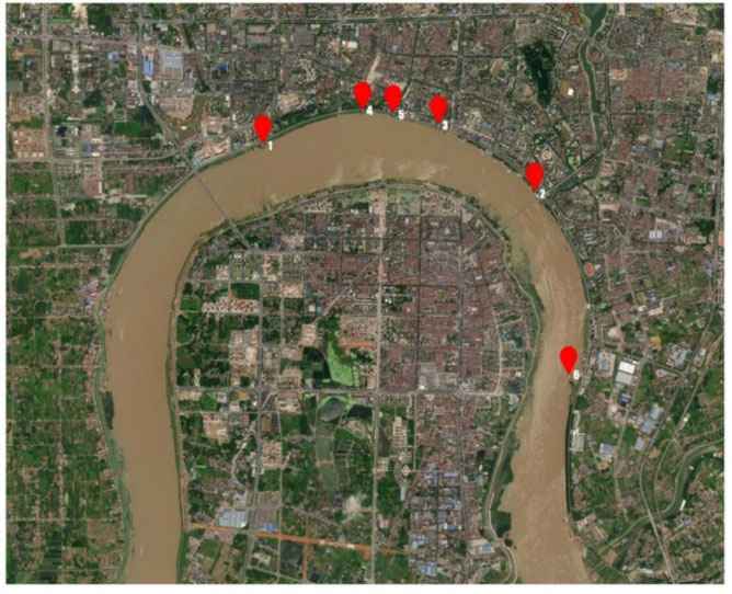
Six ancient stone marker shoreline points in Wuling District: 1 – Luolukou stone marker; 2 – Shawan stone marker; 3 – Bijia City stone marker; 4 – Huamaodi stone marker; 5 – Xiananmen stone marker; 6 – Sifeng Temple stone marker.
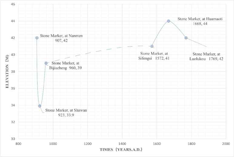
The water level elevation map of six stone markers in the historical period of Wuling District.
Only the highest water level elevation represented by the six stone markers can also show the trend of the water level elevation change in the lower Yuan River from AD 900 to AD 1800. If the elevation analysis of all the water god temples in the region is carried out, it is expected to obtain a more continuous and wider time range of the trend results of water level elevation changes, providing physical evidence for regional paleoclimate changes.
4. CONCLUSION
Through discussion of the cultural value and ancient hydrological value of the water god temples in the downstream basins of Yuan River, it is concluded that:
The ancient cultural value of water god temples is mainly manifested in religious value, economic value, transportation value and military value, while the contemporary cultural value is mainly reflected in the tourism economy. The fundamental source of the ancient cultural value of water god temples is religious belief. Because of religious belief, people gather to form business and economic points; because water god temples are usually built at the intersection of two waters, they become water transportation hubs, for water transportation safety, which also act as beacon lights; under special circumstances, the water god temples were built at high places and also played the military role of beacon towers.
The preliminary discussion on ancient hydrological value of the water god temples believes that there is a corresponding relationship between the water god temples and the ancient riverbank, and that this relationship can be used to restore the ancient river. The water god temples represented by the stone markers indicated the highest water level at that time, and the highest water level in the Five Dynasties and Ten Kingdoms Period (AD 923) reflected the extremely arid hydrological characteristics and climatic conditions at that time; during the reign of Emperor Kangxi (AD 1668), there was the largest flood period in Yuan River. If elevation analysis of all the water god temples in the region is carried out, it is expected to obtain a more continuous and wider time-scale trend of water level elevation changes, providing physical evidence for regional paleoclimate changes.
REFERENCES
Cite This Article
TY  - CONF
AU  - Dandan Zheng
AU  - Jian Kuang
PY  - 2023
DA  - 2023/01/10
TI  - Research on the Paleohydrology of the Water God Temples in the Downstream Yuan River Basin
BT  - Proceedings of the 4th International Conference on Architecture: Heritage, Traditions and Innovations (AHTI 2022)
PB  - Athena Publishing
SP  - 67
EP  - 79
SN  - 2949-8937
UR  - https://doi.org/10.55060/s.atssh.221230.010
DO  - https://doi.org/10.55060/s.atssh.221230.010
ID  - Zheng2023
ER  -


